Henry & Betty Horn's Presentation
The following is a comprehensive presentation about what we saw at Big Bend National Park complete with over 300 photographs that are labeled and interpreted. This material is copyrighted and all viewers are asked to respect this copyright.
First lets look at the document below by Henry and Betty that orients us to to their work, then perhaps print out their pdf document index to their 305 photos, and finally to the photos themselves:
Photos from Big Bend Hiking trip 21-28Jan2012
with Far Flung Outdoor Center (through Road Scholar)
by Henry and Betty Horn © 2012 (See © Fine Print at end.)
The photos are in folders by date and activity: Number of images
23AMGrapevineHillsBalRok (Balancing Rock) 16
23PMWindow 26
24PMTerlinguaGhstTwn (Ghost Town) 23
25PMSantaElenaSotol (Canyon and Vista) 36
26AMLostMine 34
26PMChisosBnBBStPk (Basin and Big Bend State Park drive) 13
Each photo is labled DateTime##H/BSubject (some HDR# &/or Pan#) where:
Date = date in January.
Time = AM, PM, or AP for all day.
## = Order of picture during the day (three digits for Hot Spring hike).
H/B = Henry or Betty as Photographer
Subject = subject.
HDR#/Pan# = # of photos combined for High Dynamic Range and/or Panorama.
zGE = Google Earth image of (or approximating) the numbered photo.
High Dynamic Range uses the software Photomatix Pro 4.0 to combine two or more photos taken at different exposures (usually one stop apart) to bring up detail in highlights and shadows and to compress the midrange. The Panoramas, some horizontal and some vertical, are stitched together using Photoshop Elements 6.0. HDRPan denotes a Panorama of several HDR images.
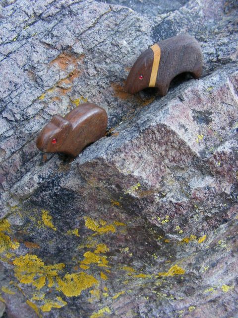
LiWA (LEE-wah) stands for my Little Wooden Animals.
We took 845 photos. After combining and purging, we saved 585 images, of which we have chosen 305 to send around, biasing toward what others may not already have photographed for themselves, specifically: aerial photos, animals, plants, hiking companions, and HDRs and Panoramas.
Enjoy! – hshorn@princeton.edu & ehorn@princeton.edu
Notes on particular photos/images (Use back arrow on Internet Browser to return)
20AP02HCloudLayers – Puffy tops and/or bottoms suggest turbulent up- and down-drafts. It is rare to see several cloud layers, more than one of which have uniform turbulence.
20AP10HRiverMeander – Note the sequential bands of vegetation that have colonized the accreting soil of the inner bend.
20AP13HContourHills – The contours are layers of limestone with alternating bands of hard and soft stone. Because the depositional layers are still flat, erosion leaves lines of resistant stone along contours of equal height.
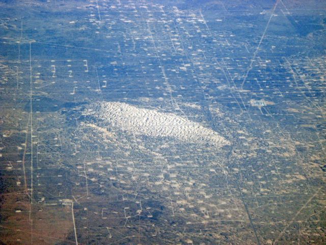
20AP17HGasOilWellsExCircle – These gas and oil wells and service roads are a tiny sample of what dominates the general vicinity of Midland TX, the Permian Basin or Bush-land. The remnant traces of irrigation circles indicate former agricultural land.
20AP19HGasOilWells – My guess is that the tightly spaced wells in the center are for oil and the more sparse peripheral wells are for gas, ... oil being more viscous than gas.
20AP20HGasOilWellsBlowout – These wells are threatened by a blow-out of shifting sand dunes.
20AP23HGuadalupeMtns – I had initially named this photo simply “rock layers,” and did not realize what it was until I located the scene in Google Earth (See next image, 20AP23zGEGuadalupeNP).
20AP24HCropCircles – Like many circular irrigation operations out west, this is right next to an area of alkaline deposits from the evaporation of mineral-laden water. It is only a matter of time before the irrigation water draws so much alkaline salts to the surface that the soil is no longer suitable for agriculture, ... if the water doesn’t run out first.
20AP25HLavaDome – I am not sure that the following Google Earth image (20AP25zGELavaDome) is this particular outcrop, but it is at least similar, and it is the closest fit that I found in the presumed search radius of our flight trajectory. It is interesting that rising blobs of magma in this region bowed up the overlying limestone, but in much of the Colorado Plateau they poked through to erupt on the surface and left the limestone layers nearly flat.
20AP29HSpacedDunePlants – The landscape first looks like a simple competitive spacing of shrubs so that they each monopolize all the rainfall that falls in a little area extending midway to the next shrub. However, the shrubs gather wind-blown sand into a mini-dune in their shelter. And they also offer some partial shade for other plants in their understory, and refuges for small animals, ... which in turn may clear the intervening areas of seeds. Similar spatially patterned communities are found in many arid areas, e.g., the clumped grasses on many slopes we saw (See 25AM45HClumpgrassHDR3.), and even the Junipers on the bajadas of the lower slopes of the Chisos Mtns (27AP03HBallJuniperZone). Human economic exploitation of uniform resources produces similarly spaced activities (See, e.g., 20AP19HGasOilWells, 27AP13zGEPecanOrchard, and 28AP12HNJSuburb).
21AP04HBearFemaleGTGrackleRIP – My LiWA visit whatever they find, even dead critters, like this car-struck female Great-tailed or Mexican Grackle.
21AP09HGTGrackles – Territorial or dominance encounters between male birds often involve brief mutual displays in which the birds point their bills skyward. Blackbirds, including these Great-tailed Grackles, carry this to an extreme and often strut about for nearly a minute with the bill raised. These two males may be disputing consortship with the nearby female, or perhaps they are showing off to her.
21AP12HGTGracklesWWDoves – In the evening screeching and squanking Grackles and White-winged Doves roosted together in huge numbers in the pines next to our hotel, and Betty and I often saw those species together during the day.
21AP18HGTGrackle – This is why they got the “great-tailed” epithet.
22AP03HMarfaPlain – This is the edge of the traditional place to see the (in)famous Marfa Lights.
22AP04HAlpineCharacter – This is Alpine’s Demosthenes, resting between soliloquies.
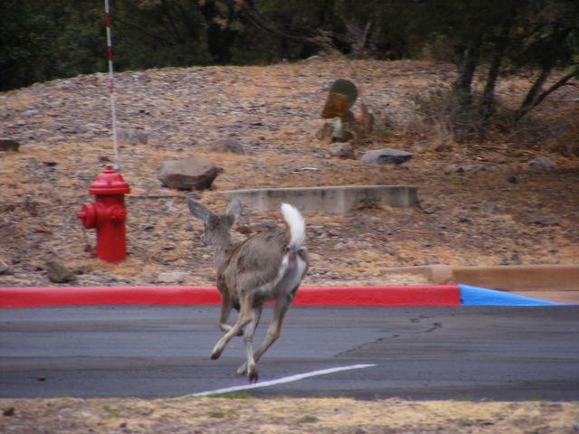
22AP45HWTDeerFlags – The white tail signals unease to alarm, and distinguishes the Carmen Mountains White-tailed Deer of the Chisos woodlands from the Black-tailed or Mule Deer of the desert lowlands.
22AP50HSaysPhoebe – This photo is a technical failure, but still catches the emotional impact of the bird’s behavior, and just enough of its field marks to nail it as Say’s Phoebe. It hunted insects from perches around the Chisos Mountains Lodge parking lot throughout our stay.
23AM31LiWAwJavelina – Two LiWA Javelinas show The Companions (Bear, Pika, Vulture, and Mountain Lion) some Prickly Pear pads that have been chewed by real Javelinas.
23PM12zHTheWindow – I like to sketch as an aid to enjoying and remembering a scene, but I seldom have the time on an organized hike. As rudimentary as this sketch is, it sealed the scene in my memory.
23PM15HWindowsHDR5 – This image illustrates both the challenge and the triumph of high-dynamic-range (HDR) digital photography. I had to freeze while taking 5 photos at different exposures, but the combined photos show detail in both distant bright haze and close deep shadows. We took MANY other photos of the scene through and framed by The Window, and except under unusual lighting conditions, the HDR images did a better job of representing our visual experience.
23PM18HLiWATenaja – I brought at least 35 LiWA with me, but to use all of them I would have had to spend more time taking pictures than hiking. So I quickly decided that the main theme of my LiWA photos would be The Companions (Bear, Pika, Vulture, and Mountain Lion) being introduced to the desert by a pair of Javelinas. Of course a crucial resource in the desert is water, and here the Javelinas show The Companions a watering hole.
23PM33HCaneChollaFruit – This is the only cactus fruit that we remember seeing, indeed about the only fruit of ANY kind.
24AM006HCoyoteCrop – This is cropped from the center of a telephoto of the two Coyotes, taken from our moving van.
24AM007HMockingbirdWC – The bird in the original photo was badly out of focus, but Photoshop®’s Watercolor Filter restored a semblance of its spirit.
24AM024DYCFlower – Both Betty and Chris agree on the identification of this flower as “DYC” = “Darned Yellow Composite.”
24AM028HLiWAAmmoniteHDR3 – I did not notice until working with this photo that there is a small Ammonite fossil just over the Vulture’s shoulder. The next photo enlarges the fossil (24AM028HLiWAAmmoniteHDR3crop).
24AM063BRioGrande – This is our only photo in which the Rio looked at all Grande.
24AM077HFemPyrrhuloxia – This is a desert version of the Cardinal, with a somewhat parrot-like bill. The name “Pyrrhuloxia” means essentially “fire-(bird) snub-(beaked).”
24AM091HRioGrandePan3 – This is the first of several panoramas, stitched together from 3 photos.
24AM092BLeatherStem – This is the plant that Patrick showed us to be a powerful oral anesthetic (See also 25AM44HLeatherstemNumbSap).
24PM36HJobuckJohnson – In my opinion, Jobuck Johnson (né Doug Schamberg) sounds very little like Willie Nelson, but he has a very pleasant demeanor and voice, and he is one heck of a guitar player; so I bought his CD in the hope of learning a few new licks.
25AM01HStaElenaCanyon – As impressive as the mouth of Santa Elena Canyon is up close, it is equally spectacular from a distance. Of course this is a telephoto, from the van on the way to the Mule Ears Spring Trail.
25AM17HIncipientTravertine – As water evaporates, calcite precipitates. Given time, pressure, and heat, it can become Travertine that fossilizes the impression of the vegetation on which it was initially deposited.
25AM20HCardinalFlower – Betty and I had a heck of a time identifying this flower head. I finally found on the WWWeb a summer photo of a Cardinal Flower taken at Mule Ear Springs, and the lower flowers had gone to seed so that they showed some parts identical to our withered spike.
25AM25zHPatricksStetson – I confess that I covet my neighbor’s hat.
25AM38H38HOcatilloGrowth – Ocatillo has different growth forms, varying from erect and straight to spread and bending to nearly horizontal. I have no idea why.
25AM44HLeatherstemNumbSap – This is a twig of Leatherstem, cut to show the sap that can be used to numb toothaches, cold sores, etc. (See also 24AM092BLeatherStem.)
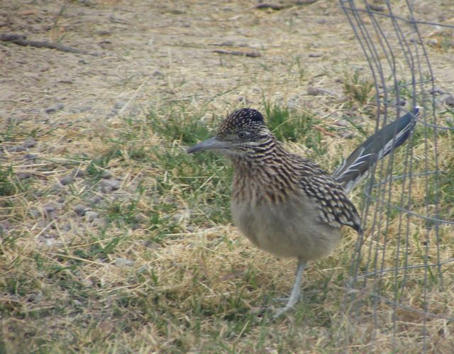
25PM32HRoadrunnerFrontal – This is the Roadrunner that folks in Patrick’s van saw when leaving the parking lot at the Hot Springs. This photo shows a lizard’s-eye view; the other is a more traditional pose (25PM33HRoadrunnerSide).
25PM37HSotolVistaHDRPan12 – This image combines 12 separate photos, 4 HDR images of 3 photos each, into a single panorama, ... and it only covers about a third of the horizon, let alone the field of view!
25PM41HCactusWrens – Many wrens remain in mating pairs throughout the year; so I am guessing that these are the resident pair for the vicinity of the Lodge. We also saw and heard Rock Wrens in most shady canyons, including within The Window, where there was also a Canyon Wren.
25PM44HWTDeerFlags – For years I have tried to shoot-from-the-hip a clear picture of a White-tailed Deer fleeing with its alarm flag high. This is one of the best I have, … in a parking lot!
25PM50HSnowOverTheWindow & following photos 54 55 – A painter could do worse than simply camping for an extended period at The Window and trying to capture its many moods.
26AM10HLiWALichens – I have hundreds of photos, from many places, of my LiWA Pika inspecting Lichens. I hope eventually to write a children’s story titled Why Does Pika Like a Lichen?
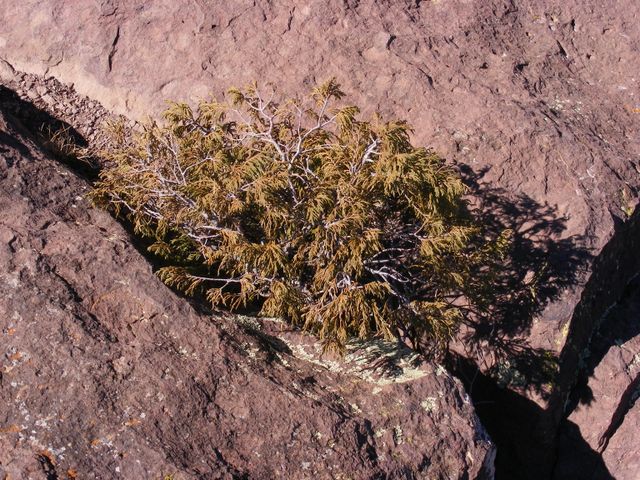
26AM24HGrassInRockCrack – One’s first reaction is “How brave and hardy this plant is in such an inhospitable spot.” However, the rock may funnel meager rain and nutrients in windblown dust to make the crack much more favorable to plant growth than would be an otherwise equivalent patch of continuous soil. Even trees can get established in such cracks (See 26PM02BJuniperInRockCrack).
26AM34zCasa Grande – Again, this sketch may not have great artistic merit, but it ensures an enduring memory.
26AM36BRufousCrwnSparrow – This apparently fearless Rufous-crowned Sparrow was very interested in the crumbs that fell from Mark’s lunch.
26Am49HCasaGrandeNSSlopesHDR3 – You could not ask for a better picture contrasting the vegetation and soil on the ultra-dry south-facing slope versus the relatively cool and moist north face. The difference even shows in Google Earth (See 26AM49zGELostMineTrail).
26AM53HCutePod – Betty and I have not yet identified this pod and the one in the following photo, but they were so elegant and floral that we had to record them.
26PM04HAcornWoodpecker – We saw this bird on Patrick’s tour of the Chisos Basin Loop Trail. The photo is feeble, but the complete red cap is enough to nail its identification as Acorn Woodpecker.
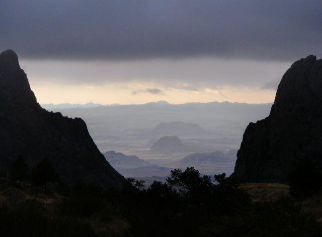
26PM11HHill – This is THE Hill in Big Bend State Park. Our sole regret for the whole week was that we did not have enough time for several short walks on this drive. Well, ... that and the fact that we missed seeing the Mountain Lion!
26PM22StudyButteTerlingua – This and the next photo of a tall Yucca and the Moon (26PM23HYuccaMoon) were taken at our Brisket Feast at the Study Butte Community Center.
27AP13HPecanOrchard – This is the closest I came to recording the regular geometry of the orchard at 75 m.p.h.
28AP06DelawareH2OGap – The Delaware Water Gap is where the Rio Delaware cuts through Kittatiny Ridge, the front rumple of the Appalachians, and it marks our return to New Jersey. Unfortunately, the smoggy haze is typical for this section of the country.
Credits
Sponsors/Organizers: Road Scholars & Far Flung Outdoor Center
Leader/Singer: Patrick Harris
Guide/Poet: Chris Tschacher
Guide/Philosopher: Cynta de Narvaez
Guitar/Vocals: Jobuck Johnson
Photographic Details: Fuji FinePix s700, 7.1 MPx, 10X zoom; Canon PowerShot A570is, 7.1 MPx, 4X zoom; Canon 0.7X Wide Converter Lens WC-DC52; iMac with 2.16 GHz Intel Core Duo, running OSX Version 10.2.8, Adobe Photoshop Elements Version 6.0; Photomatix Pro Version 4.0.1; Google earth Version 6.0.1.5001.
Maps & Brochures: Big Bend National Park (www.nps.gov/bibe).
Books:
Barr, Nevada, 2009, Borderline – Set in Big Bend National Park and vicinity, this gripping murder mystery visits and memorably uses every site that we did; 1993, Track of the Cat – ... and you KNOW which “cat.” This is set in Guadalupe National Park, east of El Paso and north-north-west of Big Bend National Park. Incidentally, the three high Chisos Mountain Trails that we hiked were closed “until further notice” at 8:00 a.m. 06.Feb.2012, due to a Mountain Lion attack the previous day, on a six-year-old boy who “received non-life-threatening injuries.” The attack happened in the afternoon, between the Dining Room and the Lodge, ... though it is interesting to follow sequential newspaper reports that transfer it to “camping in the back-country.”
Mathews, D., and J. S. Jackson, 2007, America from the Air: A guide to the landscape along your route, Houghton Mifflin, Boston and New York. This has little to say about the specific route between Houston and El Paso, but it is filled with general insights and examples from elsewhere of what one can see in aerial views of west Texas.
Miles, E., 1976, Tales of the Big Bend, Texas A. & M. University Press, College Station, TX. We have yet to read this, but we look forward to it, ... perhaps on a cold and stormy night, ... or maybe while watching refracted car lights floating over the parking lot of a local mall, ... just to get in the right mood!
Tyler, R. C., 1996 (republ. from 1975), The Big Bend: a history of the last Texas frontier, Texas A. & M. University Press, College Station, TX. This is a well-written, comprehensive, and enlightening history up until about 40 years ago. It is especially strong on those subjects for which I have found the WWWeb weak.
Wauer, R. H. and C. M. Fleming, 2002, Naturalist’s Big Bend: an introduction to the trees and shrubs, wildflowers, cacti, mammals, birds, reptiles and amphibians, fish, and insects, Texas A. & M. University Press, College Station, TX. Although this is neither elementary nor comprehensive, it gives a pretty good listing of the commoner species and some details of their distribution, with introductory insights into each group of organisms, and an extensive bibliography for further information.
© Fine Print: The formal notice of copyright means that promulgating our images under just your own name, or making a profit from them without richly rewarding the photographers, is, in a legally binding sense, very, very naughty. Private social and educational uses under Fair Use Doctrine are fine, as is advertising use by Road Scholars, Far Flung Outdoor Center, or the National Park Service, as long as the photographers are credited. – Henry S. Horn & Elizabeth G. Horn.